History and Status
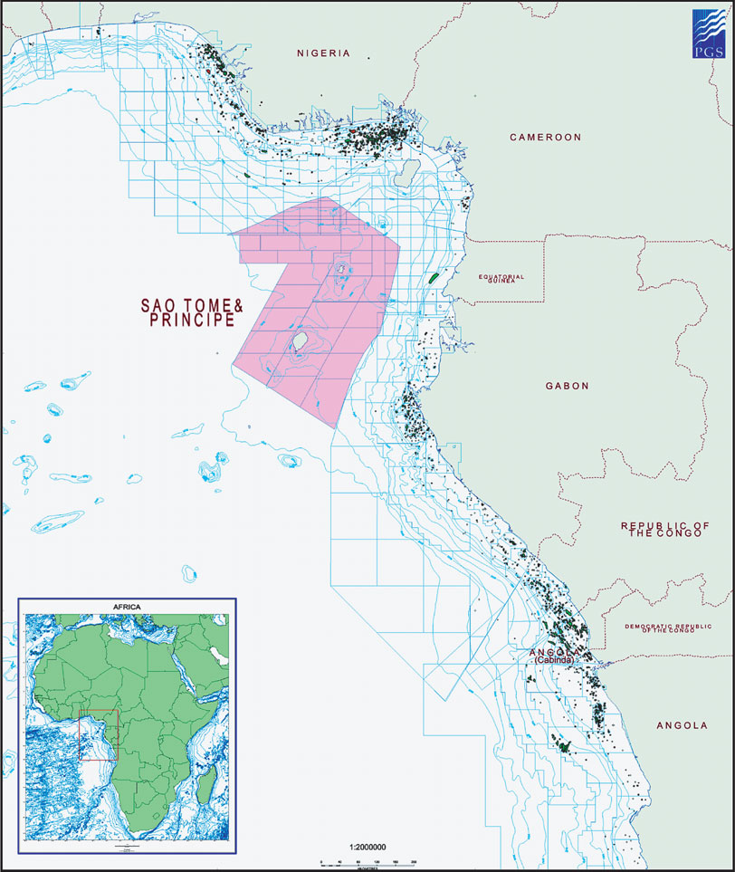
The maritime boundaries of S‹o TomŽ & Pr’ncipe (ÔSTPÕ) encompass an area of approximately 160,000 square kilometres. The proximity of STPÕs offshore waters to the proven hydrocarbon systems in the adjacent waters of Nigeria, Cameroon, Equatorial Guinea and Gabon suggests the potential for hydrocarbons, which is further supported by regional seismic data and petroleum seeps seen on the islands.
In a joint venture with Petroleum Geo-Services ASA (ÔPGSÕ), Equator partly funded the acquisition in 2001 and 2005 of 10,000 kilometres of 2D seismic data within the Exclusive Economic Zone (ÔEEZÕ) of STP. It had been agreed with the government that licences for the seismic data would be sold to oil companies to promote a licensing round. In return for the risk taken in investing in the seismic acquisition programme, the joint venture gained the right to acquire a 100% interest in two blocks of its choice. Subsequently, the Company bought out PGS to gain the right wholly for itself.
The first Licensing Round for the EEZ took place in 2010. Prior to this, the government invited the Company to make its first choice of two blocks. Equator was duly allocated its chosen blocks, Block 5 and Block 12. The PSC for Block 5 was signed with the National Petroleum Agency on the 18 April 2012 triggering the payment of a signature bonus of US$ 2 million, the provision of a performance guarantee for US$ 5.2 million and commitment to a four year work programme of seismic acquisition and studies.
In 2012, Equator purchased a licence for the 2D seismic data covering Blocks 5 and 12 and, with the help of RPS Energy, the Company carried out a comprehensive study on the prospectivity and economics of the blocks.
In 2014, under an amendment to the existing seismic license, the Company engaged PGS to reprocess the 2D seismic data set with state of the art computing algorithms. Furthermore, PGSÕs existing gravity and magnetic data was added to the license. Using the data, three specialist interpretation firms (ERCL, Getech and IGI) conducted a new comprehensive study of the block. The resulting revised geological interpretation enhanced the probability of the existence of a working petroleum system.
An Environmental Impact Assessment was made for submission to the government in preparation for a 3D seismic survey.
The National Petroleum Agency granted a request from the Company to amend the PSC by reducing the 2D obligation by 1500 km in return for increasing of the 3D seismic obligation by 200 sq km to 1200 sq km.
As part of its social obligation under the PSC, the Company supplied 8 school buses to the Ministry of Education, Culture, and Science in order to greatly shorten the journey times for high school students living in remote rural areas. The Company also funded overseas training courses for a number of staff in the National Petroleum Agency.
Activity in 2015
In 1H 2015, Equator acquired and processed 1,480 sq km of 3D seismic data over the area of prime interest in Block 5 along the Kribi fracture zone via a risk sharing contract with a consortium of BGP and Geoex. Equator also renegotiated and eliminated the 2D seismic data acquisition requirement under the PSC and replacing it with the additional 3D seismic data acquired during the acquisition survey.
As part of our commitment to training under the PSC, Equator granted Scholarships to students at the University Institute of Accounting, Administration and Information Technology in S‹o TomŽ city.
In December 2015, the Company entered into two farm out agreements with Kosmos Energy. The transaction consisted of a transfer of a 65% participating interest in each of Blocks 5 and 12 in return for a cash consideration of US$ 7.4 million to equalize past costs, a net carry on seismic liabilities of US$ 6.6m million and a 50% carry up to US$ 9.0 million on each of the commitment wells for both Phases II and III of the Exploration Period for Block 5 plus a carry of US$ 2.0 million of EquatorÕs portion of costs for Block 12. Equator retains participating interests of 20% and 22.5% in Blocks 5 and 12 respectively with the obligation to fund its share of the government interest of 15% for Block 5 and 12.5% for Block 12.
Post period activities
In February 2016, Equator secured governmental consent for the farm out of Block 5 and concluded the PSC negotiations on Block 12. The closure documents for Block 5 were executed at a signing ceremony with the ANP-STP on the 19th February 2016. ANP-STP granted a one year extension to Phase 1 of the Exploration Period. Governmental consent for Block 12 was secured in March 2016 and subsequently the transaction documents were executed on the 31st of March 2016. The initial Phase 1 of the Exploration Period of the PSC of Block 12 has a duration of four years and carries an obligation to acquire 3D seismic, magnetic and gravity surveys covering 2,000 sq km and to perform geological and environmental studies. Operatorship status was transferred to Kosmos Energy on both blocks.
On 16 November 2016, ANP granted a further two year extension to Phase 1 of the Exploration Period for Block 5 which now expires in May 2019. On 13 December 2016, Kosmos assigned 20% of its interests in Block 5 and Block 12 to Galp retaining a 45% interest in each block. EquatorÕs interests were not affected.
In February 2017, Kosmos started a large combined 3D seismic survey over Blocks 5 and 12 and over Blocks 6 and 11, in which the Company has no interest. The survey is planned to cover some 16,800 sq km of which 2,567 sq km will be in Block 5 and 4,117 sq km in Block 12. The survey is proceeding well and is due to be complete by August 2017. The survey then has to be processed before a new and definitive evaluation of the blocks can be undertaken. With the exception of geological studies the obligation for Phase 1 of the PSC is in effect complete for both blocks.
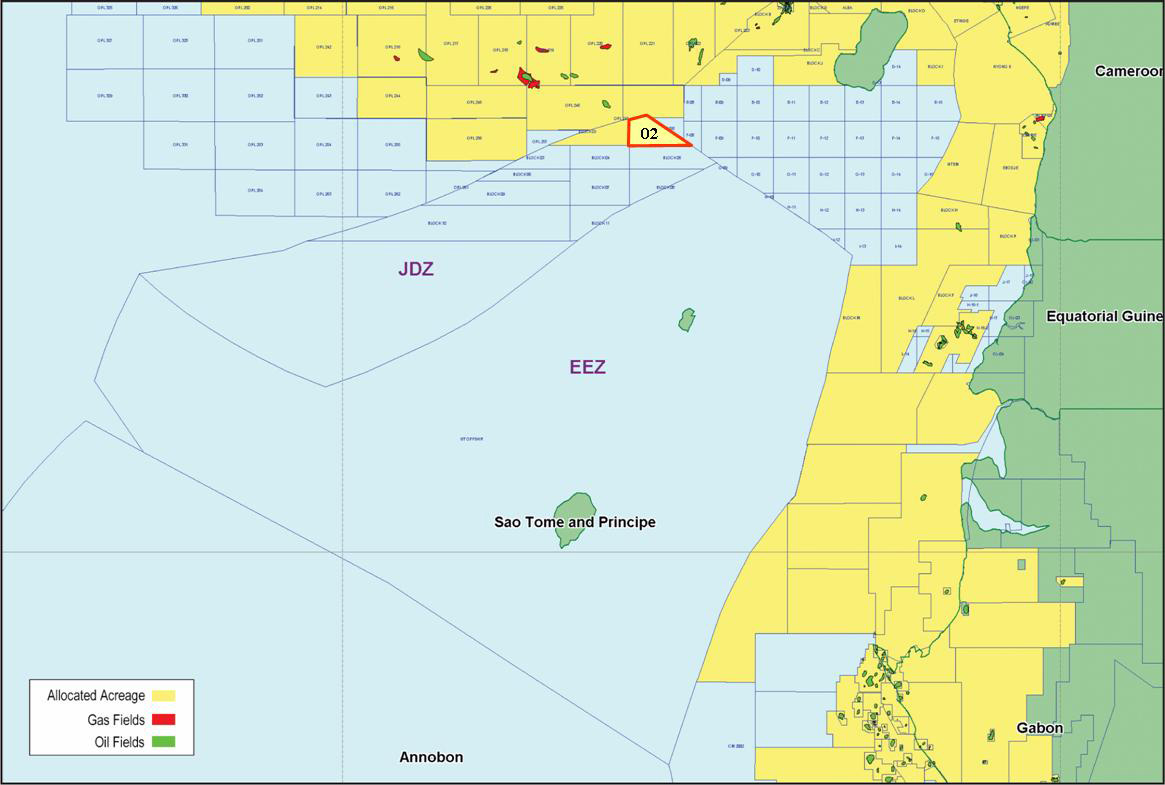
Block 5 prospectivity
Block 5 has an area of 2844 sq km and is located east of the island of Pr’ncipe, adjacent to the Equatorial Guinean shelf with water depths ranging from 2000 to 2500m. The block is within Zone A of the governmentÕs block classification scheme and is ranked highest by Equator based on the criteria of water depth, on proximity to the Equatorial Guinea shelf and to the ancient Ogouee delta, and on the presence of Cretaceous structural traps related to basement faulting. The structure of the block is dominated by the Kribi Fracture Zone Complex. Our license for 2D seismic data includes approximately 1500 line km within Block 5 on a spacing of some 2.5km by 5km. The quality of data is generally good in both the Tertiary and Cretaceous intervals.
In 2014, the block was re-evaluated. The 2D seismic data was reprocessed and ship borne gravity and magnetic data was licensed. This data has provided new insights into the understanding of the geology of the block and, in particular, the nature and history of the Kribi Fracture Zone. Regionally, source rocks are geochemically proven in the Albian-Turonian. Modelling of the maturity of two intervals of source rocks indicates that they have become early to mid-mature over most of the block. The main area of the source kitchen is in the furrow of the Kribi Fracture Zone coinciding with the location of the reservoir structures created by the Fracture Zone. The dominant hydrocarbon phase expelled is oil.
Seven horizons within the Cretaceous and Tertiary Periods were mapped in time and depth. A number of prospects and leads were identified in the section from the Albian through to the Upper Cretaceous, predominantly associated with structural trapping geometries over the Kribi Fracture Zone. Further opportunities exist within large stratigraphic leads in the Upper Cretaceous and potentially the Tertiary.
The results of the 2014 study were used to design a 3D seismic survey undertaken in 1H 2015. The 3D seismic survey improved the definition of the prospects within block 5 and lowered the estimation of exploration risk. Some preliminary AVO analysis proved encouraging. The results further affirmed the prospectivity of the block. The 2017 3D seismic survey which covers a larger area than the survey acquired in 2015 is expected to provide even better definition of the prospects. Interpretation of this survey will be completed in 2018.
Block 12 prospectivity
Block 12 is the most south-easterly block in the EEZ with an area of 7940 sq km in water depths ranging from 2500 to 3000m. It is the closest to the North Gabon salt basin, lying some 150 km to the west of Port Gentil. The block is situated within Zone B of the government block classification scheme, and within this group has been ranked the most attractive by Equator due to its proximity to the North Gabon salt basin and the presence of structural prospects located both on the footwall of the Ascension Fault and similar sub-parallel trends.
Within Block 12, we licensed approximately 800 km of 2D line data on a spacing of some 11km by 40 km. The seismic data shows reasonable reflection continuity, although the line spacing in this area is much greater than in Block 5. The seven seismic mapping horizons defined in the 2012 study of Block 5 were correlated into Block 12 through the use of the regional tie lines and a number of prospects and leads have been identified. Large robust closures exist within the Block associated with the main Ascension Transform Fault zone. Middle to Late Cretaceous synrift and post rift sedimentation has resulted in numerous interesting structured prospects. Clastics in the Miocene may also provide exploration potential.
Full investigation of the stratigraphic potential of the block (deepwater turbidite plays for example) will be achieved with the current 2017 3D seismic survey. Processing and interpretation will be completed in 2018.
|